Geologic Map of Io
Colorful Map Details Volcano-Studded Surface of Io
by Adam Mann, Wired science, March 20, 2012
http://www.wired.com/wiredscience/2012/03/jupiter-io-moon-map/
D. A. Williams, L. P. Keszthelyi, D. A. Crown, J. A. Yff,
W. L. Jaeger, P. M. Schenk, P. E. Geissler, and T. L.
Becker, 2012, Geologic Map of Io. U.S. Geological
Survey Scientific Investigations Map no. 3168.
http://pubs.usgs.gov/sim/3168/
PDf file at http://pubs.usgs.gov/sim/3168/sim3168_sheet.pdf
Yours,
Paul H.

Friday 30 March 2012
Thursday 29 March 2012
The Mysterious Hico Structure, Hamilton-Erath Counties, Texas by Paul V. Heinrich
The Mysterious Hico Structure, Hamilton-Erath Counties, Texas
by Paul V. Heinrich
Within Texas, credible proposals have been made for the extraterrestrial impact origin of six geological structures. Convincing cases have been made for three of these structures, i.e. Marquez structure (Leon County), Odessa crater (Ector County), and Sierra Madera (Pecos County), of being of impact origin (Gibson 1990; Littlefield et al. 2007; Howard et al. 1972; Wilshire et al. 1968; Wong 2001). The Bee Bluff structure in Zavala County, Texas, is disputed (Sharpton and Nielsen 1988; Jurena et al. 2001). Another proposed Texas impact structure, the Wilbarger structure in Wilbarger County, has been discredited by detailed field research (Nelson 2006). The origin of the last of these structures, the Hico structure, which lies in Hamilton-Erath County, remains an unresolved mystery.
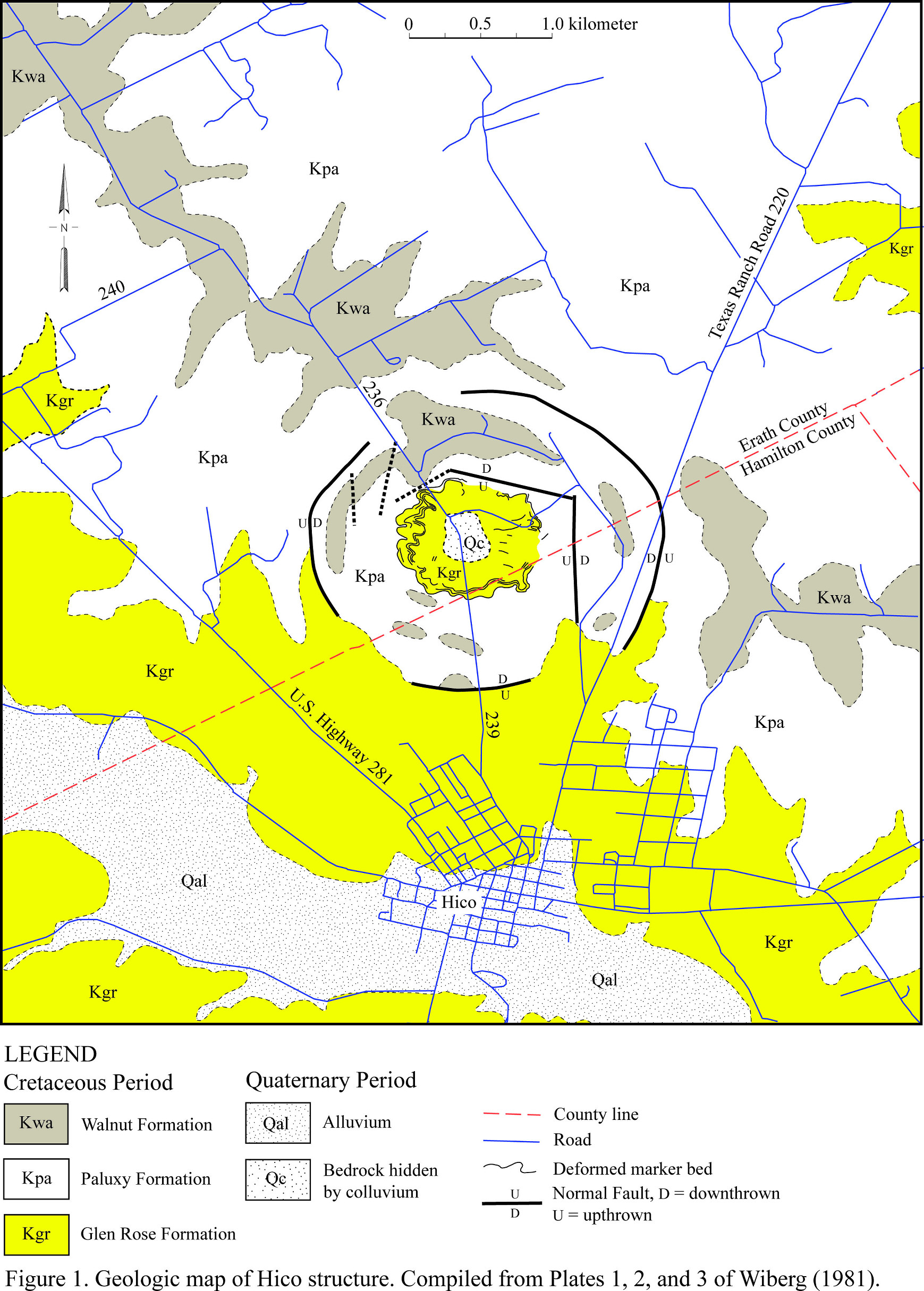
The Hico structure is a circular disturbance that is developed in Lower Cretaceous strata, upper Glen Rose, Paluxy, and lower Walnut formations about 3 km (1.8 miles) north of Hico, Texas and 32.085 degrees north latitude and 98.0342 degrees west longitude. On aerial photographs, it appears as a circular feature about 3 km (1.8 miles) in diameter (see map). The arc segments comprising this anomaly consists of tree lines and drainages associated with ring-like troughs, which encircle the central uplift of the Hico structure. On Landsat imagery, the Hico structure is at the center of a subtle 9-km (5.5-mile) in diameter circular feature (Wiberg 1981, 1982; Milton 1987).
Mr. William J. McBride first discovered the Hico structure in 1953 while mapping the geology of Hamilton County for Humble Oil and Refining Company. In 1956, they drilled the center of this structure looking for oil and gas. Unfortunately, well logs and other data acquired during the drilling of this well and McBride’s original report were lost in a warehouse fire (Wiberg 1981). If copies either of the report, well logs, seismic sections, and other data were archived elsewhere and survived the fire and could be located, they might provide invaluable data concerning the origin of the Hico structure.
Later, Mr. Oscar Monnig, a Fort Worth meteorite collector and amateur astronomer, pointed out this enigmatic structure to Dr. James R. Underwood, who at the time was a professor for West Texas State University, as a potential impact structure. Later, Dr. Underwood suggested to Ms. L. Wiberg that the Hico structure would be a suitable subject of study for a master’s thesis at Texas Christian University. This research yielded Wiberg (1981, 1982) and Milton (1987). Approximately twenty years after Wilson (1981, 1982), Heggy et al. (2004) examined the Hico structure using ground penetrating radar and analysis of SRTM Digital Elevation Model.
Local Geology
The bedrock, in which the Hico structure has developed, consists predominately of nearly horizontal, Lower Cretaceous marls, limestone, and sandstone, which dips about 3.5 m per km (18.5 ft per mile) towards the southeast (Figure 1). The oldest strata exposed within the vicinity of the Hico structure is 24 m (79 ft), which belongs to the upper Glen Rose formation, of micritic and fossiliferous limestone alternating with resistant beds of marls. Overlying the Glen Rose Formation is 15 to 20 m (49 to 66 ft) of reddish brown, friable sandstone, which contain hematite concretions, of the Paluxy Formation. Some 40 m (130 ft) of the lower and middle Walnut Formation, which consists of calcareous clays and thin-bedded limestones overlies the Paluxy Formation and outcrops in the vicinity of the Hico structure. Both the Paluxy and Walnut formations contained distinctive limestone and sandstone marker beds, which were used to map the deformation of strata within the Hico structure in detail (Wiberg 1981; Milton 1987).
Structure
As interpreted by Wiberg (1981, 1982) and Milton (1987), the Hico structure consists of a circular feature, about 3 km (1.8 miles) in diameter, consisting of a central uplift and a ring graben (Figure 1). In addition, they noted that the Hico structure lies at the center of a subtle 9-km (5.5-mile) in diameter circular feature of uncertain origin.
The central uplift of the Hico structure, as illustrated by Wiberg (1981) and Milton (1987), consists of outer and medial zones of circumferential folding surrounding the center of the structure, which is hidden by colluvial deposits (Figure 1). The outer zone of folding consists of open, undulating “pie-crust” folds, which are defined by the marker beds recognized by Wiberg (1981). Towards the center of the feature, these folds become tighter to form a medial zone of chevron folds with axes radial to center of the Hico structure. These folds consist of vertical or near-vertical beds of Glen Rose limestone. Holocene and Quaternary colluvial deposits blanket the center of the central uplift. As result, neither the age nor the structure of the rocks comprising the center of this structure is known. Wiberg (1981) and Milton (1987) suspects that the bedrock within the center consist of Pennsylvanian age sandstones of the Twin Mountain Formation, which have been uplifted by as much as 80 m (260 ft) (Wiberg 1981, 1982; Milton 1987).
Wiberg (1981, 1982) and Milton (1987) argue that a ring graben surrounds the central uplift. They concluded that the outer boundary of this ring graben is defined by a series of major faults, which are part of a ring fault (Figure 1). The inner boundary of this graben consists of numerous obscured faults, which have small displacement ranging from 8 to 18 m (26 to 59 feet). Within the ring graben, erosional outliers of Walnut Formation have been downfaulted into Paluxy and Glen Rose Formation. Although largely obscured by alluvial and colluvial deposits, circumferential folding also appears to be present within the ring graben (Wiberg 1981, 1982; Milton 1987).
Wiberg (1981) reported observing a subtle 9-km (5.5-mile) in diameter circular feature, within which the Hico structure lies at it center, in Landsat imagery. She was unable to find a geological explanation for this feature.
Later, Heggy et al. (2004) examined the Digital Elevation Model (DEM) constructed from the Shuttle Radar Topography Mission (SRTM) data. They found three previously unrecognized topographic rings, of which the outermost one is 5 to 6 km (3 to 3.7 miles) in diameter. Ground penetrating radar study of these rings indicated that these rings are controlled by ring faults similar to those that form the outer boundary on the ring graben.
They concluded that the outermost ring represents the true diameter of the Hico structure. They make no mention of the 9-km (5.5-mile) in diameter feature observed by Wiberg (1981).
Evidence of Shock Metamorphism
Wiberg (1981) collected samples of a marker bed composed of calcite-cemented sandstone from outcrops of folded Paluxy Formation exposed in the central uplift of the Hico structure. Powered samples of this sandstone were analyzed using x-ray diffraction. No indication of coesite, a high-pressure form of quartz created by extraterrestrial impacts, was found in these samples. She also prepared samples of sandstone and limestone from the folded strata from the central uplift. She found a lack of any evidence of shock metamorphism in either the sandstone or limestone samples (Wiberg 1981, 1982; Milton 1987).
Milton (1987) examined two borrow pits exposing friable limestone of the Glen Rose Formation within the central uplift. In one borrow pit, she found surfaces exhibiting convergent striations. Although the striations are irregular due the friable nature of the limestone, they were interpreted by Milton (1987) to be shatter cones.
Geophysical Surveys
Wiberg (1981) acquired gravity and magnetic data along transects across the Hico structure. Analyses of this geophysical data revealed neither gravity nor magnetic anomalies associated with its central uplift. She did find weak Bouger gravity anomalies associated with the ring faults associated with the ring graben (Wiberg 1981, 1982; Milton 1987).
Discussion
According to the Spray and Hines (2007), the principal criteria for determining if a geological feature is an impact structure formed by the hypervelocity impact of a meteorite or comet are (1.) presence of shatter cones, (2.) presence of shocked quartz with multiple planar deformation features within in situ minerals, (3.) presence of high-pressure mineral polymorphs within in situ minerals, (4.) morphometry of the structure, (5.) presence of an impact melt sheet and/or dikes, and impact melt breccias, and the presence of impact pseudotachylyte and breccias associated with radial and concentric fault systems. So far in terms of these criteria, only the morphometry of the Hico structure and report of shatter cones by Milton (1987) having been found in a borrow pit appear to meet these criteria. Unfortunately, Milton (1987) provides neither the detail descriptions nor photographs needed to document the occurrence of shatter cones. As a result, the existing published evidence is inadequate and insufficient to demonstrate the existence of shatter cones associated with the Hico structure.
The morphometry of the Hico structure is generally regarded as insufficient proof of its impact origin. Unfortunately, circular terrestrial structures, e.g., volcanoes, salt diapirs, glacigenic features are generated by numerous other means, so the Hico structure’s circular morphometry is not sufficient to prove impact structure status. However, as discussed by Wiberg (1981, 1982) and Milton (1987), the internal structure, which includes a ring graben and central uplift, of the Hico structure is quite similar to known impact structures. This and the lack of any plausible non-impact mechanisms for its origin, strongly indicate, but do not prove, that it is an extraterrestrial impact structure.
Conclusions
Although conclusive evidence for the extraterrestrial impact origin of the Hico structure is still yet to be found, it appears that it is quite likely an extraterrestrial impact structure. The search for definitive evidence of shock metamorphism associated with the Hico structure is still incomplete and more research needs to be done. First, the identity of the bedrock underlying the center of this structure still needs to be determined. Finding uplifted and deformed Pennsylvanian bedrock beneath the colluvium covering the center of this structure will greatly strengthen the case for the impact origin of this structure. In addition, it is within the strata underlying the center of the Hico structure where the best chance for finding shocked quartz exists. Finally, the shattered cones reported by Milton (1978) need to verified and better documented before they can be accepted as proof of the impact origin of this structure.
In addition, another unanswered question is the significance of the 9 km in diameter feature reported by Wiberg (1981). The existence and origin of this circular feature was completely ignored by Heggy et al. (2004)’s investigation of smaller circular features. Whether it is real, how it formed, and what is its relation to the Hico structure remains an unresolved mystery.
Paul V. Heinrich
Louisiana Geological Survey
Louisiana State University
Baton Rouge, LA 70803
Acknowledgments
I thank Douglas Carlson, Assistant Professor of Research, Louisiana Geological Survey for taking the time to review this article and his advice on how to improve it.
References Cited:Littlefield, D. L., P. T. Bauman, and A. Molineux. 2007. Analysis of formation of the Odessa crater, International Journal of Impact Engineering, v. 34, pp. 1953–1961.
Gibson, J. W. 1990. Marquez Dome - an impact in Leon County, Texas. Unpublished M.S. thesis, University of Houston, Houston, Texas, 65 p.
Heggy, E., F. F. Horz, A. Reid, S. A. Hall, and C. Chan. 2004. Potential of radar imaging and sounding methods in mapping heavily eroded impact craters: mapping the Hico Crater. 35th Lunar and Planetary Science Conference, abstract no. 1462, Lunar and Planetary Institute, Houston, Texas. http://www.lpi.usra.edu/meetings/lpsc2004/pdf/1462.pdf, 224 KB PDF file, last visited on September 28, 2007.
Howard, K. A. T. W. Offield, and H. G. Wilshire. 1972. Structure of Sierra Madera, Texas, as a guide to central peaks of lunar craters. Geological Society of America Bulletin, v. 83, pp. 2795–2808.
Jurena D., B. M. French, and M. J. Gaffey. 2001. Planar Deformation Feature Orientations and Distribution in Quartz Grains from the Carrizo Sand Formation in South Texas: Relation to the Bee Bluff Structure. Lunar and Planetary Science XXII abstract no. 1828. Lunar and Planetary Institute, Houston, Texas.
Nelson, J. 2006. personal communication, November 2006, Illinois State Geological Survey, Champaign, Illinois.
Milton, L. W.. 1987. The Hico impact structure of north-central Texas. in pp. 131-140, J. Pohl, ed., Research in Terrestrial Impact Structures. University of Munchen, Munich, Federal Republic of Germany.
Sharpton, V. L., and D. C. Nielsen. 1988. Is the Bee Bluff structure in South Texas an impact crater? In Lunar and Planetary Science XIX. Lunar and Planetary Institute, Houston, Texas. pp. 1065-1066.
Spray, J., and J. Hines. 2007. Earth Impact Database. http://www.unb.ca/passc/ImpactDatabase/index.html, last visited on September 28, 2007.
Wiberg, L. 1981. The Hico Structure; a possible astrobleme in north-central Texas, U.S.A. Unpublished M.S. thesis, Texas Christian University: Fort Worth, Texas, 75 p.
Wiberg, L. 1982. The Hico Structure: a Possible Impact Structure in North-Central Texas, USA. 13th Lunar and Planetary Science Conference, Lunar and Planetary Institute, Houston, Texas, p. 863-864.
Wilshire, H. G., and K. A. Howard. 1968. Structural patterns in central uplifts of cryptoexplosion structures as typified by Sierra Madera. Science, v. 162, p. 258-261.
Wong, W. A. 2001. Reconstruction of the subsurface structure of the Marquez impact crater in Leon County, Texas, USA, based on well-log and gravity data. Meteoritics & Planetary Science, v. 36, no. 11, p.1443-1455.
This article is a re-print from the Houston Gem and Mineral Society Bulletin,
and it is published with permission.
by Paul V. Heinrich
Within Texas, credible proposals have been made for the extraterrestrial impact origin of six geological structures. Convincing cases have been made for three of these structures, i.e. Marquez structure (Leon County), Odessa crater (Ector County), and Sierra Madera (Pecos County), of being of impact origin (Gibson 1990; Littlefield et al. 2007; Howard et al. 1972; Wilshire et al. 1968; Wong 2001). The Bee Bluff structure in Zavala County, Texas, is disputed (Sharpton and Nielsen 1988; Jurena et al. 2001). Another proposed Texas impact structure, the Wilbarger structure in Wilbarger County, has been discredited by detailed field research (Nelson 2006). The origin of the last of these structures, the Hico structure, which lies in Hamilton-Erath County, remains an unresolved mystery.
The Hico structure is a circular disturbance that is developed in Lower Cretaceous strata, upper Glen Rose, Paluxy, and lower Walnut formations about 3 km (1.8 miles) north of Hico, Texas and 32.085 degrees north latitude and 98.0342 degrees west longitude. On aerial photographs, it appears as a circular feature about 3 km (1.8 miles) in diameter (see map). The arc segments comprising this anomaly consists of tree lines and drainages associated with ring-like troughs, which encircle the central uplift of the Hico structure. On Landsat imagery, the Hico structure is at the center of a subtle 9-km (5.5-mile) in diameter circular feature (Wiberg 1981, 1982; Milton 1987).
Map of the Hico structure, Hamilton-Erath Counties, Texas
(Click the image to open a high-res map in a new window)
History(Click the image to open a high-res map in a new window)
Mr. William J. McBride first discovered the Hico structure in 1953 while mapping the geology of Hamilton County for Humble Oil and Refining Company. In 1956, they drilled the center of this structure looking for oil and gas. Unfortunately, well logs and other data acquired during the drilling of this well and McBride’s original report were lost in a warehouse fire (Wiberg 1981). If copies either of the report, well logs, seismic sections, and other data were archived elsewhere and survived the fire and could be located, they might provide invaluable data concerning the origin of the Hico structure.
Later, Mr. Oscar Monnig, a Fort Worth meteorite collector and amateur astronomer, pointed out this enigmatic structure to Dr. James R. Underwood, who at the time was a professor for West Texas State University, as a potential impact structure. Later, Dr. Underwood suggested to Ms. L. Wiberg that the Hico structure would be a suitable subject of study for a master’s thesis at Texas Christian University. This research yielded Wiberg (1981, 1982) and Milton (1987). Approximately twenty years after Wilson (1981, 1982), Heggy et al. (2004) examined the Hico structure using ground penetrating radar and analysis of SRTM Digital Elevation Model.
Local Geology
The bedrock, in which the Hico structure has developed, consists predominately of nearly horizontal, Lower Cretaceous marls, limestone, and sandstone, which dips about 3.5 m per km (18.5 ft per mile) towards the southeast (Figure 1). The oldest strata exposed within the vicinity of the Hico structure is 24 m (79 ft), which belongs to the upper Glen Rose formation, of micritic and fossiliferous limestone alternating with resistant beds of marls. Overlying the Glen Rose Formation is 15 to 20 m (49 to 66 ft) of reddish brown, friable sandstone, which contain hematite concretions, of the Paluxy Formation. Some 40 m (130 ft) of the lower and middle Walnut Formation, which consists of calcareous clays and thin-bedded limestones overlies the Paluxy Formation and outcrops in the vicinity of the Hico structure. Both the Paluxy and Walnut formations contained distinctive limestone and sandstone marker beds, which were used to map the deformation of strata within the Hico structure in detail (Wiberg 1981; Milton 1987).
Structure
As interpreted by Wiberg (1981, 1982) and Milton (1987), the Hico structure consists of a circular feature, about 3 km (1.8 miles) in diameter, consisting of a central uplift and a ring graben (Figure 1). In addition, they noted that the Hico structure lies at the center of a subtle 9-km (5.5-mile) in diameter circular feature of uncertain origin.
The central uplift of the Hico structure, as illustrated by Wiberg (1981) and Milton (1987), consists of outer and medial zones of circumferential folding surrounding the center of the structure, which is hidden by colluvial deposits (Figure 1). The outer zone of folding consists of open, undulating “pie-crust” folds, which are defined by the marker beds recognized by Wiberg (1981). Towards the center of the feature, these folds become tighter to form a medial zone of chevron folds with axes radial to center of the Hico structure. These folds consist of vertical or near-vertical beds of Glen Rose limestone. Holocene and Quaternary colluvial deposits blanket the center of the central uplift. As result, neither the age nor the structure of the rocks comprising the center of this structure is known. Wiberg (1981) and Milton (1987) suspects that the bedrock within the center consist of Pennsylvanian age sandstones of the Twin Mountain Formation, which have been uplifted by as much as 80 m (260 ft) (Wiberg 1981, 1982; Milton 1987).
Wiberg (1981, 1982) and Milton (1987) argue that a ring graben surrounds the central uplift. They concluded that the outer boundary of this ring graben is defined by a series of major faults, which are part of a ring fault (Figure 1). The inner boundary of this graben consists of numerous obscured faults, which have small displacement ranging from 8 to 18 m (26 to 59 feet). Within the ring graben, erosional outliers of Walnut Formation have been downfaulted into Paluxy and Glen Rose Formation. Although largely obscured by alluvial and colluvial deposits, circumferential folding also appears to be present within the ring graben (Wiberg 1981, 1982; Milton 1987).
Wiberg (1981) reported observing a subtle 9-km (5.5-mile) in diameter circular feature, within which the Hico structure lies at it center, in Landsat imagery. She was unable to find a geological explanation for this feature.
Later, Heggy et al. (2004) examined the Digital Elevation Model (DEM) constructed from the Shuttle Radar Topography Mission (SRTM) data. They found three previously unrecognized topographic rings, of which the outermost one is 5 to 6 km (3 to 3.7 miles) in diameter. Ground penetrating radar study of these rings indicated that these rings are controlled by ring faults similar to those that form the outer boundary on the ring graben.
They concluded that the outermost ring represents the true diameter of the Hico structure. They make no mention of the 9-km (5.5-mile) in diameter feature observed by Wiberg (1981).
Evidence of Shock Metamorphism
Wiberg (1981) collected samples of a marker bed composed of calcite-cemented sandstone from outcrops of folded Paluxy Formation exposed in the central uplift of the Hico structure. Powered samples of this sandstone were analyzed using x-ray diffraction. No indication of coesite, a high-pressure form of quartz created by extraterrestrial impacts, was found in these samples. She also prepared samples of sandstone and limestone from the folded strata from the central uplift. She found a lack of any evidence of shock metamorphism in either the sandstone or limestone samples (Wiberg 1981, 1982; Milton 1987).
Milton (1987) examined two borrow pits exposing friable limestone of the Glen Rose Formation within the central uplift. In one borrow pit, she found surfaces exhibiting convergent striations. Although the striations are irregular due the friable nature of the limestone, they were interpreted by Milton (1987) to be shatter cones.
Geophysical Surveys
Wiberg (1981) acquired gravity and magnetic data along transects across the Hico structure. Analyses of this geophysical data revealed neither gravity nor magnetic anomalies associated with its central uplift. She did find weak Bouger gravity anomalies associated with the ring faults associated with the ring graben (Wiberg 1981, 1982; Milton 1987).
Discussion
According to the Spray and Hines (2007), the principal criteria for determining if a geological feature is an impact structure formed by the hypervelocity impact of a meteorite or comet are (1.) presence of shatter cones, (2.) presence of shocked quartz with multiple planar deformation features within in situ minerals, (3.) presence of high-pressure mineral polymorphs within in situ minerals, (4.) morphometry of the structure, (5.) presence of an impact melt sheet and/or dikes, and impact melt breccias, and the presence of impact pseudotachylyte and breccias associated with radial and concentric fault systems. So far in terms of these criteria, only the morphometry of the Hico structure and report of shatter cones by Milton (1987) having been found in a borrow pit appear to meet these criteria. Unfortunately, Milton (1987) provides neither the detail descriptions nor photographs needed to document the occurrence of shatter cones. As a result, the existing published evidence is inadequate and insufficient to demonstrate the existence of shatter cones associated with the Hico structure.
The morphometry of the Hico structure is generally regarded as insufficient proof of its impact origin. Unfortunately, circular terrestrial structures, e.g., volcanoes, salt diapirs, glacigenic features are generated by numerous other means, so the Hico structure’s circular morphometry is not sufficient to prove impact structure status. However, as discussed by Wiberg (1981, 1982) and Milton (1987), the internal structure, which includes a ring graben and central uplift, of the Hico structure is quite similar to known impact structures. This and the lack of any plausible non-impact mechanisms for its origin, strongly indicate, but do not prove, that it is an extraterrestrial impact structure.
Conclusions
Although conclusive evidence for the extraterrestrial impact origin of the Hico structure is still yet to be found, it appears that it is quite likely an extraterrestrial impact structure. The search for definitive evidence of shock metamorphism associated with the Hico structure is still incomplete and more research needs to be done. First, the identity of the bedrock underlying the center of this structure still needs to be determined. Finding uplifted and deformed Pennsylvanian bedrock beneath the colluvium covering the center of this structure will greatly strengthen the case for the impact origin of this structure. In addition, it is within the strata underlying the center of the Hico structure where the best chance for finding shocked quartz exists. Finally, the shattered cones reported by Milton (1978) need to verified and better documented before they can be accepted as proof of the impact origin of this structure.
In addition, another unanswered question is the significance of the 9 km in diameter feature reported by Wiberg (1981). The existence and origin of this circular feature was completely ignored by Heggy et al. (2004)’s investigation of smaller circular features. Whether it is real, how it formed, and what is its relation to the Hico structure remains an unresolved mystery.
Paul V. Heinrich
Louisiana Geological Survey
Louisiana State University
Baton Rouge, LA 70803
Acknowledgments
I thank Douglas Carlson, Assistant Professor of Research, Louisiana Geological Survey for taking the time to review this article and his advice on how to improve it.
References Cited:Littlefield, D. L., P. T. Bauman, and A. Molineux. 2007. Analysis of formation of the Odessa crater, International Journal of Impact Engineering, v. 34, pp. 1953–1961.
Gibson, J. W. 1990. Marquez Dome - an impact in Leon County, Texas. Unpublished M.S. thesis, University of Houston, Houston, Texas, 65 p.
Heggy, E., F. F. Horz, A. Reid, S. A. Hall, and C. Chan. 2004. Potential of radar imaging and sounding methods in mapping heavily eroded impact craters: mapping the Hico Crater. 35th Lunar and Planetary Science Conference, abstract no. 1462, Lunar and Planetary Institute, Houston, Texas. http://www.lpi.usra.edu/meetings/lpsc2004/pdf/1462.pdf, 224 KB PDF file, last visited on September 28, 2007.
Howard, K. A. T. W. Offield, and H. G. Wilshire. 1972. Structure of Sierra Madera, Texas, as a guide to central peaks of lunar craters. Geological Society of America Bulletin, v. 83, pp. 2795–2808.
Jurena D., B. M. French, and M. J. Gaffey. 2001. Planar Deformation Feature Orientations and Distribution in Quartz Grains from the Carrizo Sand Formation in South Texas: Relation to the Bee Bluff Structure. Lunar and Planetary Science XXII abstract no. 1828. Lunar and Planetary Institute, Houston, Texas.
Nelson, J. 2006. personal communication, November 2006, Illinois State Geological Survey, Champaign, Illinois.
Milton, L. W.. 1987. The Hico impact structure of north-central Texas. in pp. 131-140, J. Pohl, ed., Research in Terrestrial Impact Structures. University of Munchen, Munich, Federal Republic of Germany.
Sharpton, V. L., and D. C. Nielsen. 1988. Is the Bee Bluff structure in South Texas an impact crater? In Lunar and Planetary Science XIX. Lunar and Planetary Institute, Houston, Texas. pp. 1065-1066.
Spray, J., and J. Hines. 2007. Earth Impact Database. http://www.unb.ca/passc/ImpactDatabase/index.html, last visited on September 28, 2007.
Wiberg, L. 1981. The Hico Structure; a possible astrobleme in north-central Texas, U.S.A. Unpublished M.S. thesis, Texas Christian University: Fort Worth, Texas, 75 p.
Wiberg, L. 1982. The Hico Structure: a Possible Impact Structure in North-Central Texas, USA. 13th Lunar and Planetary Science Conference, Lunar and Planetary Institute, Houston, Texas, p. 863-864.
Wilshire, H. G., and K. A. Howard. 1968. Structural patterns in central uplifts of cryptoexplosion structures as typified by Sierra Madera. Science, v. 162, p. 258-261.
Wong, W. A. 2001. Reconstruction of the subsurface structure of the Marquez impact crater in Leon County, Texas, USA, based on well-log and gravity data. Meteoritics & Planetary Science, v. 36, no. 11, p.1443-1455.
This article is a re-print from the Houston Gem and Mineral Society Bulletin,
and it is published with permission.
Tuesday 27 March 2012
Harvard experts debunk meteorite discovery in Exeter
Harvard experts debunk meteorite discovery in Exeter
Harvard experts debunk meteorite discovery in Exeter,
Ulery not giving up, seeks further chemical testing
by Aaron Sanborn, Seacoast Online, March 20, 2012
http://www.seacoastonline.com/apps/pbcs.dll/article?AID=/20120320/NEWS/203200367/-1/NEWSMAP
Best wishes,
Paul H.
Harvard experts debunk meteorite discovery in Exeter,
Ulery not giving up, seeks further chemical testing
by Aaron Sanborn, Seacoast Online, March 20, 2012
http://www.seacoastonline.com/apps/pbcs.dll/article?AID=/20120320/NEWS/203200367/-1/NEWSMAP
Best wishes,
Paul H.
Monday 26 March 2012
Planet Mercury Even Weirder Than We Thought
Planet Mercury Even Weirder Than We Thought
Planet Mercury Even Weirder Than We Thought
Wired Science, by Adam Mann, March 21, 2012 |
http://www.wired.com/wiredscience/2012/03/dynamic-mercury-geology/?pid=3477&pageid=101963
http://www.wired.com/wiredscience/2012/03/dynamic-mercury-geology/?pid=3480&pageid=101963
Mercury has been 'dynamic world' by Paul Rincon
BBC News, March 21, 2012
http://www.bbc.co.uk/news/science-environment-17248776
Mercury's Surprising Core and Landscape Curiosities
ScienceDaily, March 21, 2012
http://www.sciencedaily.com/releases/2012/03/120321105505.htm
The paper is:
Zuber, M. T., D. E. Smith, and many others, 2012, Topography
of the Northern Hemisphere of Mercury from MESSENGER
Laser Altimetry. Science Express. Published Online March 21, 2012
http://www.sciencemag.org/content/early/2012/03/20/science.1218805.abstract
http://www.sciencemag.org/content/early/2012/03/20/science.1218805/suppl/DC1
MESSENGER Planetary Conference Multimedia Page
http://messenger.jhuapl.edu/news_room/presscon11_multi.html
Best wishes,
Paul H.
Friday 23 March 2012
Possible Newly Discovered Canadian Craters - Latitude and Longitude
Possible Newly Discovered Canadian Craters - Latitude and Longitude
In "Possible Newly Discovered Canadian Craters" at:
http://six.pairlist.net/pipermail/meteorite-list/2012-March/084007.html
Mike Groetz wrote
" http://www.ldnews.net/community/143564396.html "
The article at the above URL is:
Meteorite, or meteor-wrong? by Rebecca Billard - Burns
Lake Lakes District News.
The approximate locations of the crosses in the figure,
which accompanies this article, are:
1. Lat. 54.176977, Long. -125.604098
2. Lat. 54.204567, Long. -125.567531
and 3. Lat. 54.220888, Long. -125.527564
There appears to be a depression of unknown origin
at location 2. There is not much to see at the other
locations.
Best wishes,
Paul H.
Wednesday 21 March 2012
Quick Frozen Mammoths and The Younger Dryas Impact
Quick Frozen Mammoths and The Younger Dryas Impact
In the post "some choice informed creative responses
from 138 re wattsupwiththat.com blog article New
evidence supporting extraterrestrial impact at the
start of the Younger Dryas" at
http://six.pairlist.net/pipermail/meteorite-list/2012-March/083857.html
Rich Murray wrote,
"some choice informed creative comments from 138 re
wattsupwiththat.com blog article New evidence supporting
extraterrestrial impact at the start of the Younger Dryas:
Rich Murray 2012.03.13
really nice to see so much friendly, cooperative sharing of
ideas and evidence !
http://wattsupwiththat.com/2012/03/12/new-evidence-supporting-extraterrestrial-impact-in-younger-dryas/#comment-921464 "
It is nice to see people sharing evidence. Unfortunately,
sharing antiquated, discredited, and even fictional
"evidence" only adds to the general s skepticism among
Quaternary geologists and other Earth scientists about
the Younger Dryas impact. People need to vet the
material, which they are sharing, in order to make sure
that they are not recycling long-discredited pseudoscience
from Young Earth creationists, Velikovskians, and
supporters of Earth Crustal Displacement and Charles
Hapgood, and other fringe sources. Such material only
serves to detract from they credible evidence that is
presented concerning the Younger Dryas impact.
For example, in the text quoted by Richard Murray,
Myrrh wrote on March 12, 2012
“There’s a lot of muck in this. If what’s being said here
about quick-frozen not cold-adapted mamoths and
tropical forests is indicative of the conditions which
prevailed at the onset of the Younger Dryas…”
First, the “tropical forests,” which the above comment
claims existed at the “onset” of the Younger Dryas
are completely imaginary in nature. In the considerable
number of papers, monographs, and abstracts about
the paleoclimatology of Alaska and northern Siberia,
there is a complete absence of any evidence for the
existence of “tropical forests” within the Arctic region
at anytime during entire Pleistocene Epoch and even
during the preceding Pliocene Epoch as documented
in various published papers and monographs, including
Andreev et al. (2004, 2009, 2011), Brigham-Grette
et al. (2007), Ukraintseva (1993), and Velichko and
Nechaev (2005).
Similarly, there is an abundance of published research,
which soundly refute the various claims about “not
cold-adapted mammoths” which is a favorite claim
of Young Earth creationists, i.e. Hans Krause and
Joseph C. Dillow, and various fringe catastrophists,
i.e. Ted Holden, as being quite scientifically illiterate.
This is discussed by Philip R. Burns in “Woolly
Mammoths: Suited for Cold?” at
http://www.talkorigins.org/faqs/mammoths.html#burns
in http://www.talkorigins.org/faqs/mammoths.html
Myrrh also stated,
“Second, the well-preserved mammoths and
rhinoceroses must have been completely frozen
soon after death or their soft, internal parts would
have quickly decomposed.”
If a person reads what has been published about the
mummified mammoths, rhinoceroses, and other large
mammals, which have been found in the permafrost
of Alaska and Siberia, they will find an abundance of
evidence that they are not as well preserved as Myrrh
falsely imagines and incorrectly believes them to be.
In the published literature, i.e. Farrand (1961, 1962)
and Kurten (1986), there is ample documentation and
evidence that the majority of mummified mammoths,
bison, and other large mammals suffered appreciable
decomposition before being entombed in permafrost.
In a number of cases, i.e. “Blue Babe” (Guthrie 1988),
there is solid evidence of scavenging before freezing
and burial. Some examples are;
I. Zimmerman and Tedford (1976), about tissue
recovered from a mammoth mummy in Alaska, stated:
"Abstract. Histologic examination of rehydrated tissue
samples from late Pleistocene Alaskan) mammal
mummies demonstrates that the preservative effect of
freezing and drying extends to remains 15,000 to
25,000 years old. Some muscle and liver retained
identifiable histologic structures. Most tissues were
completely disintegrated and partly replaced by
masses of bacteria, an indication of considerable
postmortem decay before the remains were
entombed beneath the permafrost zone."
II. Kurtn (1986), about one Siberian mammoth
mummy, wrote:
"Various legends exist about frozen mammoths. It as
been said, for instance, that the scientists who excavated
the Beresovka mammoth, discovered in the year 1900,
enjoyed a banquet on mammoth steak. What really
appears to have happened (as I was told by Professor
Anatol Heintz) is that one of them made a heroic
attempt to take a bite out of the 40,000 year old meat
but was unable to keep it down, in spite of a generous
use of spices."
and III. Kurtn (1986), about another Siberian
mammoth mummy, noted that Otto Herz, a zoologist
at the Imperial Academy of Sciences in St. Petersburg,
published an account about the expedition to the
Beresovka River to salvage the mammoth carcass
that had been discovered there in 1900. In this
account, Otto Herz clearly stated that only the
superficial part of this mammoth mummy had been
preserved and that its internal organs had rotted
away before the animal had become frozen.
Kurten (1986) provides a detailed explanation about
how the frozen mummies of mammoths formed
without the need to invoke an extraterrestrial
catastrophe of some sort.
The idea that these mammoths were "flash-frozen
at 150 below", as suggested by both Myrrh and
in another post by "Caleb" is nothing more than
Young Earth creationist pseudoscience as pointed
out by Farrand (1961, 1962) and other paleontologists
and Earth scientists.
Finally, they also overlook the fact that the various
mummies of mammoths and other large mammals
range in age from 9,700 BP to greater than 39,000 BP.
The majority of mummified mammoth and other
mammal remains are far too old to have any
association to a hypothetical Younger Dryas impact
event. Some of the dates for mummified remains
found in the permafrost are reported in Ukraintseva
(1993) and “Woolly Mammoths Remains: Catastrophic
Origins?” by Sue Bishop at
http://www.talkorigins.org/faqs/mammoths.html
From "Frozen Mammoths", Myrrh quoted,
"Muck. Muck is a major geological mystery. It covers
one-seventh of the earth’s land surface all surrounding
the Arctic Ocean. Muck occupies treeless, generally
flat terrain, with no surrounding mountains from
which the muck could have eroded. Russian
geologists have in some places drilled through 4,000
feet of muck without hitting solid rock. Where did
so much eroded material come from?"
As with the mummified mammoths, the "Frozen
Mammoths," has its facts either wrong or grossly
misinterpreted. The so-called " muck," which this
article talks about is permafrost that is developed
in a wide variety of sediments ranging in age from
Holocene and Pleistocene to Cretaceous and a large
variety of sedimentary deposits well-documented
to have been deposited by a wide variety of
depositional, i. e. alluvial, deltaic, lacustrine, Aeolian,
and other processes. The age and origin of what Walt
Brown, the author of this article, calls "muck" is
well known and documented and not a mystery. The
"tropical forest" described in the quote is not tropical
and is Cretaceous in age and unrelated to any younger
Dryas impact as many studies of the regional
geology have demonstrated.
It is important to note that the article, “Frozen
Mammoths,” which is found at
http://www.grahamkendall.net/Unsorted_files-2/A312-Frozen_Mammoths.txt
and is quoted by Myrrhis, is a direct reprint of a
chapter from the Young Earth creationist book
"In the Beginning: Compelling Evidence for
Creation and the Flood," by Dr. Walt Brown at:
http://www.creationscience.com/onlinebook/FrozenMammoths2.html
Both “Frozen Mammoths” and other chapters in
Walt Brown's book consists of Young Earth
creationist pseudoscience which was fabricated to
support Walt Brown's hydroplate "theory." Citing
such scientifically illiterate writings certainly does
absolutely nothing to enhance the credibility of
the Younger Dryas impact theory.
In another post, which Richard Murray quoted, Steve
Garcia stated:
“Accounts from early expeditions exist, if not exactly
journals. In 1829 German scientist G.A. Erman went
there to measure the magnetic field. Here is some of
what he said:
In New Siberia on the declivities facing the south, lie
hills 250 or 300 feet high, formed of driftwood, the
ancient origin of which, as well as the fossil wood of
the tundras, anterior to the history of the Earth in its
present state, strikes at once even the most uneducated
of hunters. . . .”
There are dangers in relying upon publications and
interpretations, which are over 180 years old. In this
case, Erman's interpretations have been greatly
revised by more recent and detailed research and the
development of absolute dating techniques and in the
understanding of sedimentology and other Earth
science disciplines. In this case, it is now very well
documented that these hills are not formed of
driftwood. Instead, they are composed of highly folded
layers of Cretaceous sand, silt, mud, clay, and brown
coal. These beds contain numerous abundant logs,
leaf prints, other plant debris, and buried forests
of upright tree trunks, which Erman confused with
driftwood (Klubov et al. 1976). The age and
sedimentology of the strata containing , Erman's
so-called "driftwood" refute any possibility that it is
associated with an Younger Dryas impact.
He further quoted G.A. Erman as stating :
“Other hills on the same island, and on Kotelnoi,
which lies further to the west, are heaped to an equal
height with skeletons of pachyderms [elephants,
rhinoceroses], bisons [sic], etc’, which are cemented
together by frozen sand as well as by strata and veins of
ice. . . . On the summit of the hills they [the trunks of
trees] lie flung upon one another in the wildest disorder,
forced upright in spite of gravitation, and with their tops
broken off or crushed, as if they had been thrown there
with great violence from the south on a bank, and there
heaped up.”
If a person consults more recent publications, i.e.
Dorofeev et al. (1999), Makeyev et al. (2003) and
Schirrmeister et al. (2010), they will find that Erman's
descriptions of hills being heaped with skeletons and
trees being flung about in the "wildest disorder" with
"their tops broken off or crushed" are greatly exaggerated
and involved a great degree of misinterpretation and
imagination that lacks any documented basis in reality.
It is true that some of the Pleistocene strata are very
fossiliferous as they contain abundant well-preserved
fossil bones (Dorofeev et al. 1999). This is a result
of them being preserved in permafrost. The majority
of both the deposits and fossil bones predate the
Younger Dryas by tens of thousands of years. Within
Kotelny Island, the Late Pleistocene and Holocene
deposits underlie terraces along streams and river
and lack any evidence of any catastrophic event
(Makeyev et al. 2003, Schirrmeister et al. 2010).
Talking about Edward von Toll, Steve Garcia stated,
“And Edward von Toll visited from 1885 to 1902, and
found them [wood hills] to cinsist of carbonized trunks
of trees, with impressions of leaves and fruits.”
As previously mentioned, the "carbonized trunks
of trees, with impressions of leaves and fruits" of the
wood hills are Cretaceous in age. Thus, it is rather
silly and counterproductive to used these fossils as
evidence of a Younger Dryas impact. Such fossil
trees even predate the Chixulube impact.
That the observations and interpretations of Edward
von Toll, Erman, and other early explorers have been
found in the decades since they were made to be quite
speculative, highly imaginative and in many cases quite
wrong. As a result, it is entirely misleading for a person
to used them as evidence for any type of catastrophe,
whether it be Walt Brown's hydroplate "theory," Charles
Hapgood's Eartrh Crustal Displacement, or a Younger
Dryas impact without mentioning that these observations
and interpretations have been in many cases discredited,
refuted, or significantly revised by later investigators
armed with numerous absolute dates and greater
understanding of geology and paleontology.
Finally, Steve Garcia stated about Edward von Toll,
“On another island Toll found mammoth bones and other
bones, plus fossilized trees with leaves and cones, making
him to write,
“This striking discovery proves that in the days when
the mammoths and rhinoceroses lived in northern
Siberia, these desolate islands were covered with
great forests, and bore luxuriant vegetation.””
Although northern Siberia was populated by abundant
mammoths and rhinoceroses and extensive boreal forests
in places during interglacial epochs, it was quite barren
and sparsely populated by large mammals during the
the glacial stages. During the Last Glacial Maximum,
(LGM) in northern Siberia consisted of rather barren
and depopulated polar desert as illustrated by Adams
(1997) and discussed by Ukraintseva (1993) and
Velichko and Nechaev (2005). This later changed
as the climate ameliorated after the peak of the LGM.
References Cited
Adams, J. M., 1997, Preliminary Vegetation Maps of
the World since the Last Glacial Maximum: An Aid to
Archaeological Understanding. Journal of
Archaeological Science. vol. 24, pp. 623–647.
http://www.esd.ornl.gov/projects/qen/new_eurasia.html
http://www.esd.ornl.gov/projects/qen/euras18k.gif
Andreev, A.A., G. Grosse, L. Schirrmeister, S. A.
Kuzmina, E. Y. Novenko, A. A. Bobrov, P. E. Tarasov,
B. P. Ilyashuk, T. V. Kuznetsova, M. Krbetschek, H.
Meyer, and V. V. Kunitsky, 2004, Late Saalian and
Eemian palaeoenvironmental history of the Bol’shoy
Lyakhovsky Island (Laptev Sea region, Arctic Siberia).
Boreas. vol. 33, pp. 319–348.
Andreev, A. A., G. Grosse, L. Schirrmeister, T. V.
Kuznetsova, S. A. Kuzmina, A. A. Bobrov, P. E.
Tarasov, E. Y. Novenko, H. Meyer, and A. Y. Derevyagin,
F. Kienast, A. Bryantseva, and V. V. Kunitsky, 2009,
Weichselian and Holocene palaeoenvironmental history
of the Bol’shoy Lyakhovsky Island, New Siberian
Archipelago, Arctic Siberia. Boreas. vol. 38, pp. 72-110.
Andreev, A. A., L. Schirrmeister, P. E. Tarasov,
A. Ganopolski, V. Brovkin, V., C. Siegert, S. Wetterich,
and H.-W. Hubberten, 2011, Vegetation and climate
history in the Laptev Sea region (Arctic Siberia) during
Late Quaternary inferred from pollen records.
Quaternary Science Reviews. vol. 30, pp. 2182–2199.
Brigham-Grette, J., M. Melles, P. Minyuk, and Party,
Scientific, 2007. Overview and significance of a 250
ka paleoclimate record from El'gygytgyn Crater Lake,
NE Russia. Journal of Paleolimnology. vol. 37, pp. 1–16.
Dorofeev, V. K., M. G. Blagoveshchensky, A. N.
Smirnov, and V.I. Ushakov, 1999, New Siberian Islands.
Geological structure and metallgeny. VNIIOkeangeologia,
St. Petersburg, Russia. 130 pp.
Farrand, W. R., 1961, Frozen Mammoths and Modern
Science. Science. vol. 133, no. 3455, pp. 729-735.
Farrand, W. R., 1962, Frozen Mammoths. Science.
vol. 137, pp. 450-451.
Guthrie, M. L., 1988, Blue Babe : The Story of a Steppe
Bison Mummy from Ice Age Alaska. University of
Chicago Press, Chicago, Illinois.
Klubov, B. A., A. A. Korshunov, and I. G. Badera, 1976,
New data on coal measures of Novaya Sibir' Island,
New Siberian. Transactions Doklady of the U.S.S.R.
Academy of Sciences: Earth Science Sections. vol. 231,
pp. 58-60.
Kurten, Bjorn, 1986, How to Deep Freeze a Mammoth.
Columbia University Press, New York, New York.
Makeyev, V. M., D. P. Ponomareva, V. V. Pitulko, G. M.
Chernova and D. V. Solovyeva, 2003, Vegetation and
Climate of the New Siberian Islands for the past
15,000 Years. Arctic, Antarctic, and Alpine Research.
vol. 35, pp. 56-66.
Schirrmeister L., G. Grosse, V. V. Kunitsky, M. C. Fuchs,
M. Krbetschek, A. A. Andreev, U. Herzschuh, O. Babyi,
C. Siegert, H. Meyer, A. Y. Derevyagin, S. Wetterich,
2010, The mystery of Bunge Land (New Siberian
Archipelago) – Implications for its formation based
on palaeo-environmental records, geomorphology
and remote sensing. Quaternary Science Reviews.
vol. 29, pp. 3598–3614.
Ukraintseva, V. V. (1993) Vegetation Cover and
Environment of the "Mammoth Epoch" in Siberia.The
Mammoth Site of Hot Springs of South Dakota, 1800
Highway 18-Truck Route, Hot Springs, SD. 309 pp.
Velichko, A. A., and V. P. Nechaev, 2005, Cenzoic
Climatic and Environmental Changes in Russia. Special
Papers no. 382. Geological Society of America. Boulder,
Colorado.
Zimmerman, M. R., and R. H. Tedford, 1976, Histologic
Structures Preserved for 21,300 Years. Science. vol. 194,
pp. 183-184.
Best wishes,
Paul H.
Monday 12 March 2012
An Impactor Origin for Lunar Magnetic Anomalies
An Impactor Origin for Lunar Magnetic Anomalies
Ancient impact may explain moon’s magnetic mystery
(Anomalies near crater suggest scattering of iron-rich
debris) by Nadia Drake, Science News, March 9th, 2012
http://www.sciencenews.org/view/generic/id/339067/title/Ancient_impact_may_explain_moon’s_magnetic_mystery
Huge Asteroid Impact Linked to Moon's Magnetic
Hotspots by Charles Q. Choi, SPACE.com< march 8, 2012
http://www.space.com/14836-asteroid-collision-moon-magnetism.html
The paper is:
Wieczorek, M. A., B. P. Weiss, and S. T. Stewart, 2012,
An Impactor Origin for Lunar Magnetic Anomalies.
Science. vol. 335, no. 6073, pp. 1212-1215
DOI: 10.1126/science.1214773
http://www.sciencemag.org/content/335/6073/1212.abstract
PDF file of this paper is downloadable from:
http://scripts.mit.edu/~paleomag/articles/Wieczorek_2012_Science.pdf
Yours,
Paul H.
Saturday 10 March 2012
Silicon Isotope Evidence Against an Enstatite Chondrite Earth
Silicon Isotope Evidence Against an Enstatite Chondrite Earth
Earth Formed From Diverse Meteorite Mix, Study Suggests
by Clara Moskowitz, SPACE.com, March 1, 2012
http://www.space.com/14752-earth-formation-meteorite-history.html
Meteorites That Made Earth Are Of Many Types, Geochemists
Report, Huffington Post, March 2, 2012
http://www.huffingtonpost.com/2012/03/02/meteorites-that-formed-earth_n_1315903.html
The paper is:
Fitoussi, C., and B. Bourdon, 2012, Silicon Isotope Evidence
Against an Enstatite Chondrite Earth. Science. Published
Online March 1 2012, Science DOI: 10.1126/science.1219509
http://www.sciencemag.org/content/early/2012/02/29/science.1219509.abstract
Best wishes,
Paul H.
Meteorites Reveal Another Way to Make Life's Components
Meteorites Reveal Another Way to Make Life's Components
Meteorites Reveal Another Way to Make Life's Components
ScienceDaily, March 9, 2012, http://www.sciencedaily.com/releases/2012/03/120309104845.htm
Meteorites Reveal Another Way to Make Life's Components
Klaus Schmidt, March 10, 2012 http://spacefellowship.com/news/art27926/meteorites-reveal-another-way-to-make-life-s-components.html
The paper is:
Burton, A. S., J. E. Elsila, M. P. Callahan, M. G. Martin, D. P.
Glavin, N. M. Johnson, and J. P. Dworkin. A propensity
for n-w-amino acids in thermally altered Antarctic
meteorites. Meteoritics & Planetary Science. Article
first published online: 8 March 2012
http://onlinelibrary.wiley.com/doi/10.1111/j.1945-5100.2012.01341.x/abstract
best wishes,
Paul H.
Meteorites Reveal Another Way to Make Life's Components
ScienceDaily, March 9, 2012, http://www.sciencedaily.com/releases/2012/03/120309104845.htm
Meteorites Reveal Another Way to Make Life's Components
Klaus Schmidt, March 10, 2012 http://spacefellowship.com/news/art27926/meteorites-reveal-another-way-to-make-life-s-components.html
The paper is:
Burton, A. S., J. E. Elsila, M. P. Callahan, M. G. Martin, D. P.
Glavin, N. M. Johnson, and J. P. Dworkin. A propensity
for n-w-amino acids in thermally altered Antarctic
meteorites. Meteoritics & Planetary Science. Article
first published online: 8 March 2012
http://onlinelibrary.wiley.com/doi/10.1111/j.1945-5100.2012.01341.x/abstract
best wishes,
Paul H.
Sunday 4 March 2012
Extraterrestrial Russian rock found
Extraterrestrial Russian rock found
Extraterrestrial Crystal Discovered in Russia's
Remote Kamchatka Peninsula, The Daily Galaxy
January 13, 2012,
http://www.dailygalaxy.com/my_weblog/2012/01/extraterrestrial-crystal-discovered-in-russias-remote-kamchatka-peninsula.html
Extraterrestrial Russian rock found, Paul Hamaker
Examiner, http://www.examiner.com/paeleontology-in-national/extraterrestrial-russian-rock-found?CID=examiner_alerts_article
The paper is:
Bindi, L., J. M. Eiler, Y. Guan, L. S. Hollister, G. MacPherson,
P. J. Steinhardt, and N. Yaoh, 2012, Evidence for the
extraterrestrial origin of a natural quasicrystal. Proceedings
of the National Academy of Science,
http://www.pnas.org/content/109/5/1396
PDF file at:
http://www.pnas.org/content/109/5/1396.full.pdf+html
Best wishes,
Paul H.
Fossilized Fruit or meteorite
Fossilized Fruit or meteorite
In "Fossilized Fruit or meteorite" at:
http://six.pairlist.net/pipermail/meteorite-list/2012-March/083646.html
Paul Gessler wrote,
“I don’t think that is a meteorite. But the “flow”
lines looked puzzling until I remembered my
experience with finding fossilized fruits on the
Queen Charlotte Islands in BC. Canada
I think it is a fossilized fruit of some sort.
Spinifructus antiquus
take a look here: sort of like a fig
http://www.plantworlds.com/images/800px-Spinifructus_antiquus_fruits_01[1].jpg "
Dear Larry and Paul,
It does look like the internal mold of some sort of fossil fruit.
It is certainly does not look like a volcanic bomb. It would
be helpful in evaluating it if some sort of context, i.e. general
location to at least the county or nearest city / town, about
where it was found, of this find could be provided.
I would suggest that you join the “Fossil Forum” at
http://www.thefossilforum.com/index.php?
After you have joined, you can get the opinion of the fossil
collectors on this forum. They would likely know what this
specimen and its possible scientific significance might be.
If this is a fossil fruit, which are quite rare, it might be of
some scientific interest
For any fossil collectors on this list, The Fossil Forum an
excellent forum to meet and learn from other amateur and
professional fossil collectors. Meteorite collectors will find
that fossil collectors have the same concerns about
government regulations and laws that they do.
Best wishes,
Paul H.
Friday 2 March 2012
Floor of Oldest Fossilized Forest Discovered
Floor of Oldest Fossilized Forest Discovered
Floor of Oldest Fossilized Forest Discovered:
385 Million Years Old, Science Daily, March 1, 2012
http://www.sciencedaily.com/releases/2012/03/120301102716.htm
Floor of oldest forest discovered in Schoharie
County, New York, Science Codex, March 1, 2012
http://www.sciencecodex.com/floor_of_oldest_forest_discovered_in_schoharie_county-87029
The paper is:
Stein, W. E., C. M. Berry, L. Van Aller Hernick,
and F. Mannolini, 2012, Surprisingly complex
community discovered in the mid-Devonian fossil
forest at Gilboa. Nature. vol. 483, no.7387, pp. 78-81.
http://www.nature.com/nature/journal/v483/n7387/full/nature10819.html
Meyer-Berthaud, B., A.-L. Decombeix, 2012,
Palaeobotany: In the shade of the oldest forest.
Nature. vol. 483, no.7387, pp. 41-42.
http://www.nature.com/nature/journal/v483/n7387/full/483041a.html
Gilboa Fossil Forest, Schoharie County, About geology,
http://geology.about.com/od/geology_ny/ig/NYgallery/NYgilboa.htm
Gilboa Fossil Forest, Wikipedia
http://en.wikipedia.org/wiki/Gilboa_Fossil_Forest
Yours,
Paul H.
Subscribe to:
Posts (Atom)